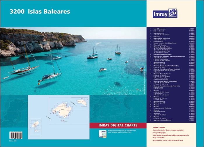
A brand new chart atlas covering the Islas Baleares - Ibiza, Formentera, Mallorca, Cabrera and Menorca. 25 sheets provide all of the necessary information for passage planning and detailed approaches to the harbours and anchorages of this appealing cruising ground. In loose-leaf A2 format in a tough plastic wallet.
Imray Digital Charts: Free mobile download
A voucher code to download the relevant Imray digital charts into Imray Navigator (our app for iPad and iPhone) is included with this atlas.
Charts included:
- Ibiza & Formentera (1:150 000)
- Ibiza Southwest (1:60 000)
- Ibiza Northwest (1:60 000) includes plan Puerto de San Antonio (1:30 000)
- Ibiza East (1:60 000)
- Ibiza South to Formentera (1:60 000) includes plan Puerto de Savina (1:10 000)
- Puerto de Ibiza (1:15 000) and Passage between Ibiza & Espalmador (1:25 000)
- Mallorca & Menorca (1:350 000)
- Mallorca - Bahía de Palma (1:50 000) includes plans Cala Portals (Portals Vells) (1:10 000), Puerto de Portals Nous (1:10 000), San Antonio de la Playa (1:10 000) & Puerto El Arenal (1:10 000)
- Puerto de Palma de Mallorca (1:17 500)
- Mallorca - Isla Dragonera to Punta de Cala Figuera (1:50 000) includes plans Puerto de Andratx (1:10 000), Puerto de Santa Ponça (1:10 000) & Puerto de Port Adriano (1:10 000)
- Mallorca - Punta S’Aliga to Puerto de Sóller (1:50 000) and Cabo Tramuntana to Punta S’Aliga (1:50 000)
- Mallorca - Puerto de Sóller to Punta Beca (1:50 000) includes plan Puerto de Sóller (1:10 000)
- Mallorca - Punta Beca to Puerto de Alcudia (1:50 000) includes plans Approaches to Port de Pollença (1:17 500) & Bonaire (1:10 000)
- Mallorca - Bahía de Alcúdia (1:50 000) includes plans Puerto de Alcudia (1:15 000), Puerto de Ca’n Picafort (1:10 000), Puerto de Serra Nova (1:10 000) & Colonia de Sant Pere (1:10 000)
- Mallorca - Cabo Ferrutx to Punta Rasa (1:50 000) includes plans Puerto de Cala Ratjada (1:7500) & Puerto de Cala Bona (1:10 000)
- Mallorca - Punta de N'Amer to Porto Petro (1:50 000) includes plans Porto Cristo (1:10 000) & Porto Colom (1:10 000)
- Mallorca - Colonia de Sant Jordi to Cala d’Or (1:50 000) includes plans Cala Llonga (1:10 000), Porto Petro (1:10 000) & Cala Figuera (1:10 000)
- Mallorca - Approaches to Cabrera (1:50 000) includes plans Puerto de Cabrera (1:12 500) & Cala Es Borri (1:15 000)
- Mallorca - Cabo Enderrocat to Cabo Blanco (1:50 000) and Cabo Blanco to Ensenada de la Rápita (1:50 000)
- Menorca (1:150 000)
- Menorca West (1:50 000) includes plan Approaches to Ciudadela (1:10 000)
- Menorca North - Islotes Bledes to Addaia (1:50 000) and Puerto de Fornells (1:15 000)
- Menorca Northeast (1:50 000) includes plan Puerto de Addaia (1:15 000)
- Menorca Southeast (1:50 000) includes plan Puerto de Mahon (1:20 000)
- Approaches to Islas Baleares (1:700 000)
A voucher code to download ID50 Imray Western Mediterranean charts into Imray Navigator (our app for iPad, iPhone and Android) is included with this atlas
| Artikelnummer | BD7090 |
|---|---|
| Haupttitel | 3200 Islas Baleares Chart Atlas |
| ISBN | 9781786790606 |
| EAN | 9781786790606 |
| Hersteller / Verlag | Imray |
| Produkttyp | App, Karte |
| Medium / Produktart | Download, Lizenzkarte, Papier |
| Kategorien | Hafenführer / Revierführer, Seekarte/Binnenkarte |
| Sprache | Englisch |
| Land / Region | Balearen |
| Gewässer | Balearen-Meer |
| Erscheinungsjahr | 2018 |
| Ausführung | In Plastikmappe |
| Kartentyp | Kartensatz - verschiedene Massstäbe |
| Plattform | iOS |
| Dimension 1 (cm) | 59,4 |
| Dimension 2 (cm) | 42 |












Validate your login
Anmelden
Neuen Account erstellen