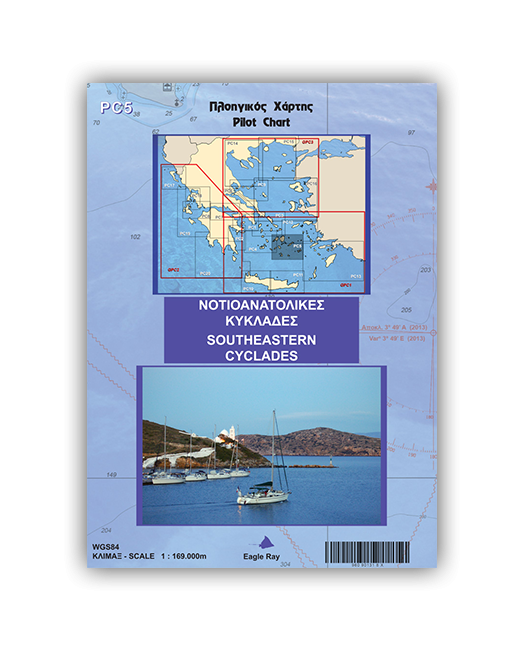
Pilot Chart PC5 - Southeastern Cyclades
- Nautical and piloting chart
- Laminated and tear resistant
- Updated with monthly NMs
- with waypoints marked in practical positions
- including local weather forecast
- the back side contains port plans
Antíparos up to Sýrna
Islands of Páros, Náxos, Amorgós, Lévitha, Síkinos, Íos, Santoríni, Anáfi, Astypálaia
- Páros – Antíparos strait and O. Paroikiá approaches
- Bay and harbour of ?áxos
- Bay and harbour of Katápola (Amorgós)
- Bays of Íos and Mylopótamos
- Approaches and harbour of Vlycháda (Santoríni)
- Ágios Nikólaos harbour (Anáfi)
- Approaches and harbour of Skála (Astypálaia)
Sportbootkarten von Eagle Ray sind Seekarte und Pilot Chart in einem. Sie sind beidseitig farbig auf wasserfestem Papier gedruckt. Zusätzlich zu den üblichen Angaben über Küstenverlauf, Wassertiefen, Seezeichen usw. enthalten sie auch Informationen über Wolkenbildungen an den Bergen und viele weitere revierbezogene Informationen. Auf der Rückseite befindet sich eine große Zahl von Plänen größerer Maßstäbe der Durchfahrten, Ankerbuchten und Häfen des Reviers. Flachwassergebiete werden blau dargestellt. Die Seezeichen auf See und an Land sind vollständig eingetragen. Die Beschriftungen, Zeichenerklärungen und Tabellen sind griechisch und englisch.
| REF | BD2683 |
|---|---|
| Nom de produit | Pilot Chart PC5 - Southeastern Cyclades |
| ISBN | 978-960-90131-8-5 |
| EAN | 9789609013185 |
| Fabricant / éditeur | Eagle Ray |
| Droit de retour | Selon nos termes et conditions |
| Type de produit | Carte |
| Type de produit | Papier |
| Catégories | Livre de bord / Livres pilotes, Carte nautique |
| Langue | Anglais, Grecque |
| Pays / Région | Grèce |
| Eaux | Mer Égée, Mer Méditerranée |
| Auteur | Nicholas D. Elias |
| Année de publication | 2018 |
| Édition | 3 |
| Type de reliure | Pliées en portefeuille plastique |
| Échelle de la carte | 1:169'000 |
| Type de cartes nautiques | 1:30'000 bis 1:300'000 |
| Longueur de la carte ouverte (cm) | 100 |
| Largeur de la carte ouverte (cm) | 70 |
| Poids (kg) | 0.13 |
| Dimension 1 (cm) | 25 |
| Dimension 2 (cm) | 17 |







Validate your login
Se connecter
Créer un nouveau compte