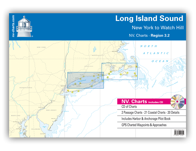
Watch Hill to New York. 2 Übersegler, 21 Küsten- und 20 Detailkarten. Format 60x42cm, Loseblatt. Mit Begleitheft "Harbour & Anchorage Pilot Book" (enthält Revierinformationen, tabellarische Infos zu den Marinas und eine Zeichenerklärung). Der Kartensatz enthält zusätzlich sämtliche Karten dieses Gebietes in digitaler Form auf CD (Rasterkarten) zur Nutzung z. B. mit den Programmen NV. Chart Navigator light/Standard/Pro oder Fugawi Marine ENC. Es ist kein Navigationsprogramm enthalten, auch keine Lightversion! Spiralbindung, in englischer Sprache, Ausgabe 2010
Passage Charts
CC0 New York to Boston 1: 1,300,000
C1 Long Island Sound 1: 340,000
Coastal Charts
C2 Execution Rocks to Stratford Shoal 1: 100,000
C3 Stratford Shoal to Falkner Island 1: 100,000
C4 Falkner Island to Gardiners Island 1: 100,000
C5 Block Island Sound 1: 100,000
C6 East River to Execution Rocks 1: 45,000
C7 Execution Rocks · Oak Neck to Stamford Harbor 1: 45,000
C8 Stamford Harbor to Cockenoe Harbor 1: 45,000
C9 Southport Harbor to Charles Island 1: 45,000
C10 Charles Island · New Haven to Branford Reef 1: 45,000
C11 Branford Reef to Clinton Harbor 1: 45,000
C12 Clinton Harbor to Old Lyme Shores 1: 45,000
C13 Old Lyme Shores to Race Rock · New London 1: 45,000
C14 Connecticut River 1: 45,000
C15 Thames River 1: 45,000
C16 Race Rock to Watch Hill · Fishers Island Sound 1: 45,000
C17 Gardiners Island to Race Rock 1: 45,000
C18 Riverhead to Jessup Neck 1: 45,000
C19 Jessup Neck to Gardiners Island 1: 45,000
C20 Gardiners Point to Montauk Pointh 1: 45,000
C21 Crab Meadow to Mt. Sinai Harbor 1: 45,000
C22 Oak Neck to Crab Meadow 1: 45,000
Details
C23 East River · Throgs Neck to Larchmont 1: 25,000
C24 Larchmont to Captain Harbor 1: 25,000
C25 Captain Harbor to Long Neck Point 1: 25,000
C26 Greens Ledge to Sherwood Point 1: 25,000
C27 Bridgeport 1: 25,000
C28 Stratford · Housatonic River Entrance 1: 25,000
C29 New Haven to Branford Reef 1: 25,000
C30 Branford Reef to Falkner Island 1: 25,000
C31 Clinton and Westbrook Harbor 1: 25,000
C32 Westbrook Harbor to Old Lyme 1: 25,000
C33 Hatchett Reef to Bartlett Reef · Niantic Bay 1: 25,000
C34 Bartlett Reef to Fishers Island 1: 25,000
C35 Mystic to Watch Hill · Fishers Island Sound 1: 25,000
C36A New London · Thames River 1: 25,000
C36B Thames River North 1: 25,000
C37 Stony Brook to Mt. Sinai Harbor 1: 25,000
C38A Cold Spring Harbor 1: 25,000
C38B Eatons Neck · Northport Hbr. and Huntington Hbr. 1: 25,000
C39A Montauk Harbor 1: 10,000
C39B Pine Island Bay 1: 10,000
| REF | BD2249 |
|---|---|
| Nom de produit | NV.Chart 3.2: Long Island Sound 2010 |
| Short Description | Kombipack Papier / Digital CD und App |
| Fabricant / éditeur | NV Charts |
| Droit de retour | Selon nos termes et conditions |
| Type de produit | Carte, Software App |
| Type de produit | CD/DVD, Papier |
| Catégories | Livre de bord / Livres pilotes, Carte nautique |
| Langue | Anglais |
| Pays / Région | USA |
| Eaux | Océan Atlantique |
| Année de publication | 2010 |
| Type de reliure | In Plastikmappe |
| Type de cartes nautiques | Jeu de cartes - différentes échelles |
| Configuration système requise | Lecteur de CD-ROM |
| Poids (kg) | 0.88 |
| Dimension 1 (cm) | 60 |
| Dimension 2 (cm) | 42 |








Validate your login
Se connecter
Créer un nouveau compte