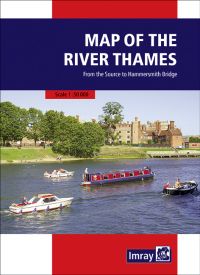
This popular map of the non-tidal Thames from its the source above Cricklade to the entrance of the Grand Union Canal at Brentford below Teddington Locks is convenient in any cockpit and is the ideal companion to Chris Cove-Smith’s River Thames Book.
Full information on boating facilities is included in the mapping, as are all the essential details on restricting dimensions, locks and bridges. Also shown are pubs, the Thames Path and other features of special interest. Large-scale insets of Oxford, Abingdon, Reading, Henley, Windsor and Eton, the River Wey junction and the entrance to the Grand Union Canal add to the clarity of this well presented map.
| Cod.Art. | 10164 |
|---|---|
| Nome prodotto | Map of the River Thames |
| Short Description | from the Source to Hammersmith Bridge |
| ISBN | 9781786792532 |
| EAN | 9781786792532 |
| Produttore / Editore | Imray |
| Diritto alla restituzione | Secondo i nostri termini e condizioni |
| Tipo di prodotto | Carta |
| Tipologia di prodotto | Carta |
| Categorie | Carta nautica |
| Lingua | Inglese |
| Paese / Regione | Inghilterra |
| Acque | Acque interne Inghilterra |
| Anno di pubblicazione | 2021 |
| Edizione | 3 |
| Tipo di rilegatura | Plissettato |
| Peso (kg) | 0.13 |


Validate your login
Registrati
Creare un nuovo account